Geography Notes: Hazardous Earth
The atmosphere operates as a global system that transfers heat around the Earth.
- Atmospheric circulation = Movement of air
- Wind movements form a clear global circulation pattern.
- Movement of air within circulation cells is controlled by heating and cooling.
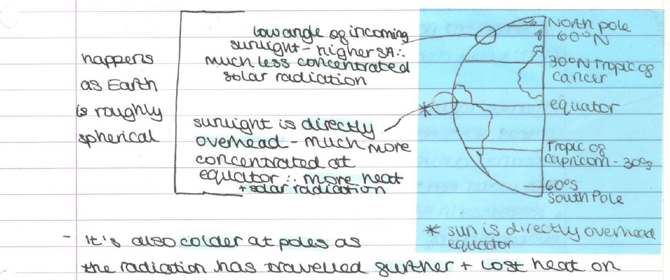
- It's also colder at the poles, as the radiation has traveled further and lost heat along the way.
- The following processes carry heat from the equator to the poles:
- Atmospheric circulation cells
- Ocean currents
- The effect of this heat transfer is to even out global temperatures between 0°C and 60°C by redistributing heat energy.
- The average temperature at the poles is -30°C, whereas at the equator, it's 30°C. This difference would be much greater if heat transfer didn't occur.
Oceanic Circulation
How do ocean currents work?
- The Great Ocean conveyor belt combines warm surface currents with cold deep ocean currents.
- Nutrients, warmth, and oxygen are transported around.
- Surface currents control the motion of the top 8% of the ocean’s water, while deep-ocean currents mobilize the other 92%.
- In Northern waters, surface water sinks as it’s frigid (and… dense). This is the driver of the circulation.
- In Southern waters, water warms and rises to the surface (it’s less dense).
Thermohaline Conveyor
- Warm, less salty water travels at the surface of oceans, driven by the surface winds blowing on top.
- This water cools as it travels north and south from the equator and increases in salinity as the salt is left behind during the evaporation of the warm water.
- This cooler, saltier water sinks and returns to the equator to balance the Earth’s heat budget.
- This is important to Western Europe as the Gulf Stream (a warm ocean current) brings warm ocean waters, warming Western Europe well beyond what it should be given its latitude.
- E.g., Newcastle has the same latitude as Moscow.
- Scientists think the thermohaline has shut down in the past; for example, at the end of the last ice age, it broke and flooded the North Atlantic with cold, fresh water, shutting off the current.
Ocean currents, Winds, and Pressure
- Winds, tides, variations in water density, and Earth's rotation drive ocean currents.
- The topography of the ocean floor and shoreline modifies these motions, causing currents to speed up, slow down, or change direction.
Winds
- Wind is the major force behind surface currents in the open ocean. As the wind blows over the sea, it drags the top layers of water.
- That moving water pulls on layers underneath, and those pull on ones below them.
- Surface winds can affect water as deep as 400m.
Atmospheric Pressure
- The weight of the air plus the space it exerts on the ground equals pressure, which greatly influences the climatic features of an area.
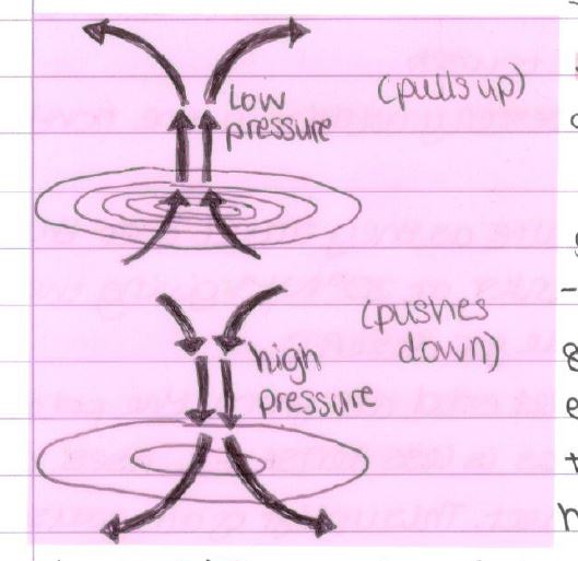
- The Earth's surface warmth heats the air above it, increasing its energy and causing it to rise.
- As air rises away from the ground, it creates low pressure at the surface.
- As the air continues to rise away from the Earth's surface, the heating effect of the warm ground is reduced, and the air begins to cool. Cooler air has less energy—it begins to sink.
- The weight of cooler sinking air exerts more pressure on the ground, and an area of high pressure is formed.
The Tri-Cellular Model
- The movement of air across the planet occurs in a specific pattern. The equator drives the entire system.
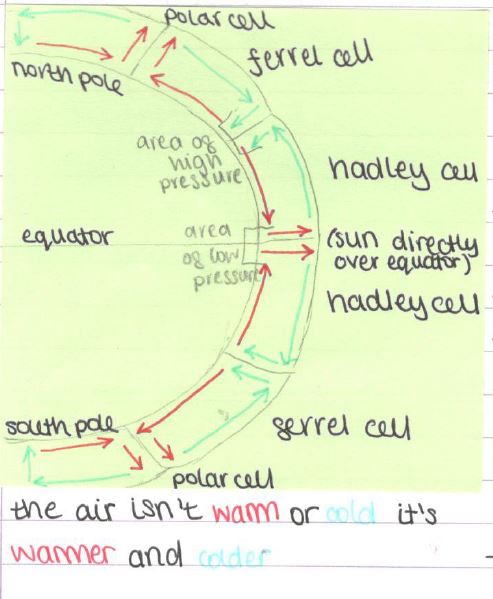
Hadley Cell:
- As the sun is always high in the sky at the equator, the ground heats up rapidly during the day.
- Hot air rises in convection currents. As it ascends, the rising air cools, forming condensation and producing cumulonimbus clouds.
- Heavy rainfall occurs once we reach the saturation point. At high altitudes, air moves poleward (ferrel cells). At 30°N/S, cooler air begins to sink back to Earth's surface.
Ferrel Cell:
- Situated between 30° and 60°.
- Air at the surface is pulled toward the poles, forming southwesterly winds in the northern hemisphere.
- These winds pick up moisture as they travel over the oceans.
- Dry air from the equator sinks at 30°N/S, giving an arid climate (suitable for deserts).
- At 60°, the winds collide with cold air from the poles. Warmer air from the tropics is less dense and rises above cold air as the 2 masses meet. This uplift of air causes low pressure to develop at the surface.
- These unstable conditions are mid-latitude depressions that are characteristically experienced in the cool-temperature Western maritime climate (CTWM).
Polar Cell:
- On the surface at the North Pole, descending air = High pressure. Air descends here: it’s cold and has a heavy density.
- The mid-latitude low-pressure belt at 60°N draws winds from the high-pressure poles.
- This (the winds) transports cold air away from high latitudes, causing warm air to be brought in by the polar cell.
- This process helps address the energy deficit.
Overview: These cells result in a broad pattern of low-pressure (rainfall) and high-pressure (rainfall) belts distributed in bands by latitude.
Air Movements
- Convection:
Solar radiation heating the ground causes air to rise. Rising air cools and condenses, forming water droplets.
- Low air pressure: Air moves up, away from the surface.
- Thick clouds and heavy rainfall.
- Subsidence:
In areas with low-intensity solar radiation (e.g., poles) or where air is cold at high altitudes, cold, dense air sinks toward the ground.
- High air pressure: Air is pulling down towards the surface.
- Little/None rainfall and thin clouds.
Global Latitude Budget (Energy Balance)
- Over a year, planet Earth absorbs the same amount of energy from the sun as it emits to space. It's in balance.
- The equator (0°) receives the majority of solar radiation, while the poles (90°) lose it.
- The cells (in the cellular model) move the solar radiation to the poles.
Natural Causes of Climate Change
- Stratosphere: Layer of air 10-50 km above Earth's surface. It's above the cloudy layer we live in (the troposphere).
- Milankovitch cycles: Natural changes to the Earth's orbit and position affecting how much radiation we receive from the sun.
Asteroid Collisions:
- Large cosmic material such as asteroids and comets impact the Earth's surface. This can eject large volumes of dust into the atmosphere (upper atmosphere).
- This has the effect of blocking out the sun's rays → The amount of solar radiation received is reduced, and the climate cools; energy from the sun is immediately and pronouncedly a cooling effect.
- Duration: Suggested back into space, but on a geological timescale, it’s a mere blip.
Orbital Changes
- Eccentricity: The orbit of the Earth changes shape over long periods of time—every 100,000 years. Sometimes it’s more circular, making us warmer, and sometimes it’s more elliptical, making us slightly cooler (~5-6°C).
- Axial tilt: The Earth is sometimes more upright and sometimes more on its side. It takes ~41,000 y for this change to occur.
- Precession: Earth’s axis wobbles as it rotates. Takes ~ 24,000y to wobble. Creates greater/smaller differences between our seasons.
- The last ice age was 18,000 years ago.
- Can have either a heating or cooling effect.
Solar Output:
- The amount of radiation the sun produces varies over time.
- Sunspots are black areas on the sun’s surface. Sometimes it has many and at other times they disappear.
- Lots of spots = More solar energy is being sent out from the sun to the Earth.
- Periods of lower solar activity → Glacial periods (e.g., Little Ice Age) and periods of higher solar activity → Interglacials (e.g., Medieval warm period—you could have vineyards).
- This affects climate change over a few hundred years and a temperature change of 1-2°C.
- There’s an 11y cycle for the no. of sunspots.
- Can have either a heating or cooling effect.
Volcanic Activity
- Large-scale volcanic eruptions can eject lots of ash and dust into the atmosphere.
- Some eruptions produce so much volcanic material and eject large quantities of dust and SO₂ (g) into the upper atmosphere—the stratosphere—where SO₂ (g) is rapidly converted into H₂SO₄ (aq) aerosols.
- Volcanic pollution (from smaller eruptions) in the lower atmosphere is removed within days by rain; the volcanic dust and aerosols in the stratosphere may remain for several years, gradually spreading over much of the globe.
- Cooling effect → Large eruptions, e.g., the Mount Pinatubo (Philippines) eruption in 1991, can bring about a global cooling of up to 0.3°C for up to 2 years.
Evidence for Natural Climate Change
- The Quaternary period began 2.6 million years ago and extends to the present day.
Definitions:
Climate: Average weather over a period of time, usually 30 years.
Weather: State of the atmosphere on a day-to-day basis.
Glacial: Long period of time during which the Earth's glaciers expanded widely.
Interglacial: A long period of warmer conditions (change).
Quaternary period: The most recent geological period of Earth's history, consisting of the Pleistocene (began 1.8m. ya and ended 10k ya) and the Holocene (most recent 10k years).
Evidence of Recent Past Climates: Historical Sources
- Historical paintings of alpine landscapes allow us to pinpoint the former extent of glaciers at precise moments.
- Time series of sea ice cover have been derived from Antarctic whaling records and from observations of drift ice around Iceland’s coast.
- Paintings recording the Thames being frozen over with fairs held on ice. In the past 200 years this hasn’t been able to happen, but between 1309 and 1814, the Thames froze over at least 23 times.
Dendrochronology
- Periods of growth can be seen through the cross-section of a tree. Scientists study tree rings to understand past climates.
- The number of tree rings tells us how old the tree is.
- The thicker the ring, the warmer the climate.
- The thinner the ring, the colder the climate.
- Trees live for 100s/1000s of years, but we can use timber from old buildings and fossilised trees to get older data.
Ice Cores
- In polar regions (e.g., Greenland and Antarctica), ice built up over hundreds of thousands of years.
- Ice is formed in layers, and as it forms, it traps bubbles of air frozen in the ice. These bubbles can tell us about the atmosphere at the time they were frozen and detect changes in temperature.
- The bubbles can be used to work out atmospheric composition at the time frozen (measures greenhouse gases).
- More CO₂ in ice = Warmer climate.
- Less CO₂ in ice = Cooler climate.
Impact of Human Activity on Global Climate
The global climate is now changing due to human activities and we're uncertain about the future.
- Greenhouse effect: A natural process that keeps the Earth warm. The atmosphere's greenhouse gases act as a blanket, trapping solar radiation that Earth radiates back to space. Without this effect, the Earth would be much colder.
- Enhanced greenhouse effect: This involves human activity increasing the amounts of greenhouse gases released into the atmosphere.
- Anthropogenic climate change occurs when Earth absorbs more solar radiation and becomes warmer.
Differences between human-enhanced greenhouse effect and natural greenhouse effect:
- Enhanced: Less heat escapes back to space.
- Enhanced: More heat is emitted back to Earth.
- Enhanced: More greenhouse gases.
1) The Earth's atmosphere receives solar radiation, some of which reflects back into space.
2) Land and oceans absorb the remaining solar energy, heating Earth.
3) Heat radiates from the Earth toward space.
4) Greenhouse gases in the atmosphere trap some of this radiative heat, keeping Earth warm enough to support life.
5) Human activities, e.g., burning fossil fuels, agriculture, and land clearing, are increasing the amount of greenhouse gases released into the atmosphere.
6) This trapping of extra heat is causing the Earth's temperature to rise, along with other effects such as ocean acidification.
Greenhouse Gases
- Since 1850, the amount of CO₂ (89% of the gas produced) has increased by approximately 30%. Sources include burning fossil fuels and deforestation.
- Methane, which accounts for 7% of greenhouse gas emissions, has increased by approximately 250% since 1850 and is 21 times more potent than CO₂. The sources of this increase include gas pipeline leaks, rice farming, and cattle farming.
- Since 1850, the production of nitrous oxide (3% of GG) has increased by 16%, making it approximately 250 times more potent than CO₂. Sources include aircraft engines, cars, lorries, sewage farms and fertilisers.
- Halocarbons, which make up 1% of GG, are approximately 3000 times more potent than CO₂. Sources include uses in industry, solvents, and cooling equipment.
Human Activities that Produce Greenhouse Gases
1) ENERGY: As the population grows and new technologies emerge, the demand for electricity surges. Burning fuels generates the majority of energy and releases various emissions. Energy use in homes, offices, and other buildings produces CO₂.
2) INDUSTRY: As disposable income rises, there is an increased demand for the production of consumer goods, which leads to more industrial growth and a greater need for energy, resulting in the burning of more fossil fuels. Halocarbons are released.
3) TRANSPORT: As cars become more affordable and more people opt for short and long-distance flights, they consume a significant amount of fuel. Almost all transport relies on burning fossil fuels. Nitrous oxide is released.
4) FARMING: Population growth - Higher demand for food production. Mechanisation - More fossil fuels burnt, intense cattle farming and rice farms produce more gases. Methane is released.
Evidence for Climate Change
Sea level rise:
- Since 1870, sea levels have risen by 200 mm due to a combination of factors such as thermal expansion, ocean water expanding as temperature rises, melting ice sheets, and glaciers on land, including those in Greenland, Antarctica, and mountain ranges.
- The temperature of ocean surface waters has increased by 0.8°C since 1980, which has had a significant impact on the distribution of various fish species.
Global temperature rise:
- The global temperature in 2010 was approximately 0.65°C higher than in 1980 and 1°C higher than in 1970.
- Some places like the Arctic are 2-3°C warmer.
Declined artic ice:
- The amount of floating sea ice in the Arctic Ocean has decreased by approximately 35% since 1979, leading to fewer warmer summers.
- Arctic sea ice plays a crucial role in regulating Earth's temperature. The melting of Earth's snow and ice cover results in a decrease in the reflectivity of the Earth's surface, known as albedo.
- The Earth's climate system warms as a result of this decrease in sunlight reflection back into space.
Increased extreme weather events:
- There's some evidence flooding and storms are becoming stronger and more frequent (in 100 years, floods and storms become more frequent than expected).
- → One disastrous event every 50 years → 20 years.
- → More flash flooding—shorter lag time on storm hydrograph.
Impacts on Developed and Developing Countries
UK (Developed country):
- Increased cost of protecting low-lying areas, e.g., London and East Anglia, from rising sea levels.
- Frequent heatwaves (e.g., summer 2003) have increased the cost to the NHS due to health issues.
- Flood events, such as those in the summer of 2007 and the winter of 2012, have become more frequent and costly.
- The Scottish skiing industry is likely to disappear.
- Farmers may change crops (potatoes and wheat → maize and grapes); irrigation costs could rise.
- New bird and animal species migrate to the UK.
- As the sea temperature rises, fish species undergo changes, such as cod leaving the North Sea.
- Increased storminess = More erosion on coasts (e.g., Holderness).
Bangladesh (Developing country):
- Rising sea levels could cause 10% of Bangladesh's land to disappear, leaving people landless and facing food shortages. 10% live less than 1m above sea level.
- There are severe water shortages due to the failure of the monsoon rains, which is compounded by hunger.
- Cyclones in the Bay of Bengal are becoming more frequent and stronger. Rising sea levels → Erode the country’s vital coastal mangrove swamps.
- NW Bangladesh could be more prone to drought.
- Increased rainfall and meltwater from Himalayan glaciers can make flooding more common, leading to the destruction of homes and crops.
- Impacts on Bangladesh are much more severe than in the UK. This is it; it impacts most people and is more long-term. They can't manage it (financial instability) and can't mitigate it either (can't change the weather).
Uncertainty for the Future
Physical Processes: Oceans can absorb a lot of CO₂, but saturation may reduce their ability. The Arctic's shrinking sea ice and snow cover absorb more solar radiation rather than reflecting it, intensifying warming. Greenland and Antarctic ice sheets may start melting more, rapidly increasing global sea levels. A warmer world creates clouds, which reflect solar radiation back to space, thereby reducing global warming.
Human Reasons: The world’s population growth rate in the future is unknown. The average wealth of people in the future has no correlation with emissions per person. People may either make a significant effort to reduce emissions or continue to pollute. Global initiatives may have an impact on deforestation rates. New technologies could replace fossil fuels and reduce emissions.
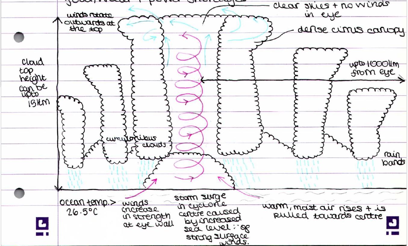
How Tropical Cyclones are Caused
- Typhoons, tropical cyclones, and hurricanes are tropical storms.
- Warm oceans form tropical cyclones because the heat and moisture in these waters provide the energy to raise sea surface temperatures.
To develop, temperatures usually need to be >26.5°C to develop.
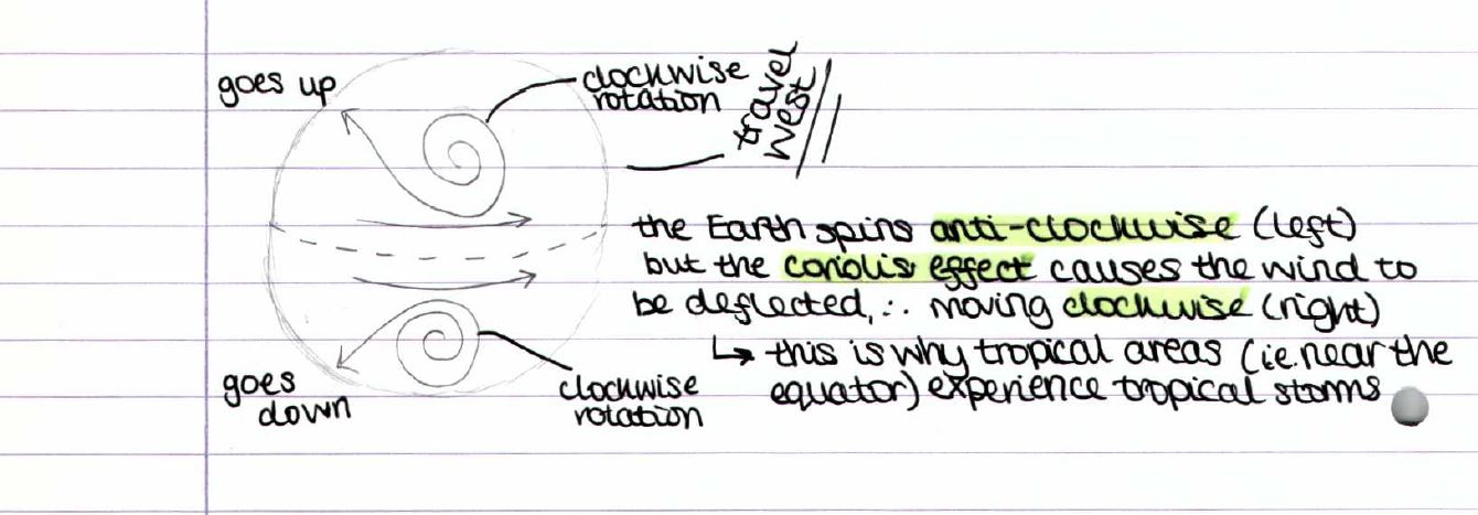
- They travel west from the equator (N/S).
- Only tropical regions of the Earth are affected (5°-90°N/S of the equator).
- Tropical cyclones are intense, rotating, low-pressure wind and storm systems that form over oceans.
- Scientists predict that with climate change, there will be more in the future.
How they’re formed:
- High temperatures cause air to rise away from the ocean surface.
- Rising air → Thunderstorms.
- These storms group together, and a strong blow of warm, rapidly rising air produces an area of extreme low pressure at the center of the converging air. For this to happen, these conditions must be met:
Source of warm, moist air > 26.5°C
This is the time of year when the ocean water is at its warmest.
Winds converging at the ocean surface cause the air to rise.
Storms away from the equator can rotate due to the Coriolis effect.
Continued
Features of tropical storms:
1) Warm, moist air uplift creates a dense canopy of cumulus clouds above the cyclone.
2) Swinging in the centre allows high banks of clouds to stretch out. Strong winds and heavy rain stretch out 1000 kilometres from the cyclone centre.
3) The eye typically has clear skies and no winds.
4) Spiral appearance.
5) A thick bank of clouds rises 15 km into the atmosphere from the centre (the eye and the area around it). The eyewall has the heaviest rain and the strongest winds.
Threats to humans:
- The high wind speeds and storm surges can cause structural damage.
Major loss of life and significant damage (> cat. 3).
Flooding can cause damage to both property and the environment, such as the coast.
Food, water, and power shortages.
How Global Circulation Leads to Tropical Cyclones:
- Winds blow from high to low pressure.
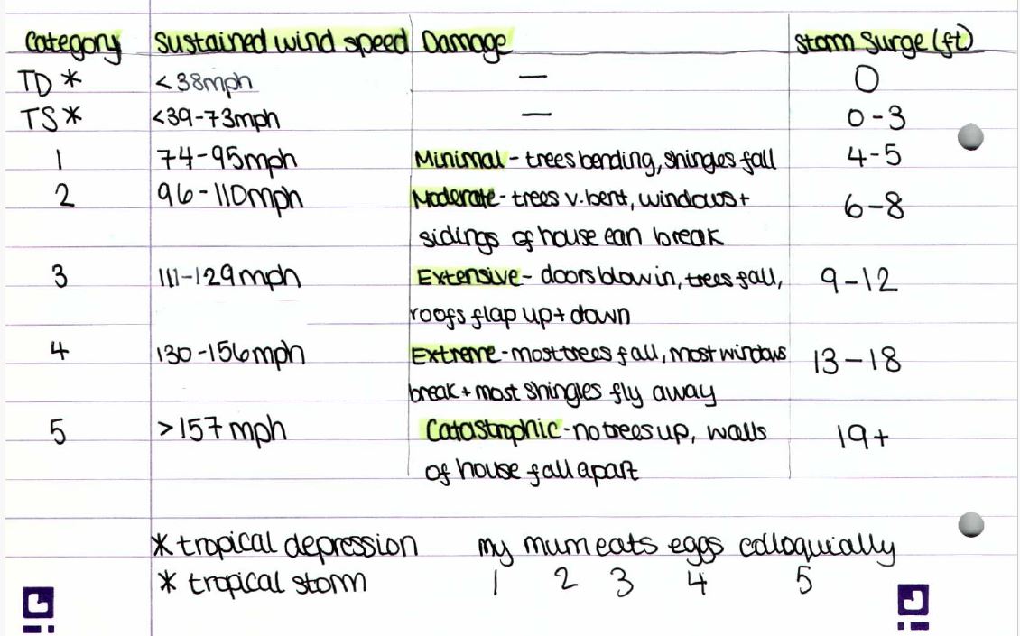
Saffir-Simpson Scale
- Tropical storms are classified using categories linked to wind speed (sustained).
The North Atlantic and Northeastern Pacific regions use this scale.
Dissipation of tropical cyclones:
Dissipation: When the tropical cyclone loses energy and decreases in intensity.
This can happen for three main reasons:
1) When it reaches land, it loses energy and its fuel source is warm water.
2) It moves into cooler water areas with no fuel source.
3) Runs into other weather systems where the wind is blowing in different directions (Pulled apart).
→ Tropical cyclones can only form if the winds throughout the atmosphere's layers are blowing in the same general direction. Winds can shift their direction and intensity at different times. The tropical cyclone may start to pull apart layers of the atmosphere.
If a tropical cyclone makes landfall on an island, it'll begin to dissipate, but as the track takes it back over water again, the cyclone can re-intensify as it regains its fuel source.
It usually takes 7 to 14 days for a tropical cyclone to dissipate into a normal low-pressure weather system. However, if the tropical cyclone passes over mountainous areas, it’ll weaken much more quickly.
This results in the release of huge quantities of rainfall, which can lead to floods and landslides.
Different names for tropical storms:
North America: Hurricanes.
South America: Tropical cyclones
Typhoons: NE Asia
Tropical cyclones: Australia, Eastern Africa, South Asia.
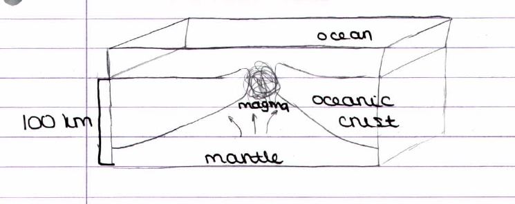
Earth’s Structure
OCEANIC CRUST: The thinnest layer of Earth, averaging 6 to 10 km thick and solid.
CONTINENTAL CRUST: The much thicker layer with an average of 35 to 40 km thick but can be up to 70 km thick underneath mountain chains, solid (we live here).
MANTLE: Semi-molten (neither liquid nor solid). Molten rock, or magma, is 2900 km thick. Magma plays a crucial role in the process of continental drift, moving at a slow pace through convection. The movement of continental plates relies heavily on magma. Temperature reach around 5000°C.
INNER CORE: Made of iron and nickel. The temperature at the core is 6200°C, located 6371 km beneath the Earth's surface. Most liquids solidify under extreme pressure; scientists believe this layer is solid.
OUTER CORE: Hot, electrically conducting liquid. Mainly made of iron and nickel, it creates Earth's magnetic field, around 2200 km thick.
How the Core Creates Convection Currents
- Tectonic plates move very slowly, 2 cm/year.
Radioactive decay causes high temperatures in the core,
which in turn generates heat and causes movement.
- The magnetosphere, a massive, invisible magnetic field, surrounds Earth.
The magnetosphere, created by the outer core, functions as an electrical dynamo, producing a magnetic field as it flows.
- The radioactive decay of uranium and thorium creates an internal heat source in the Earth's core. Radioactive decay occurs over time.
- Convection currents in the mantle drive heat transfer from one part of a liquid or gas to another.
- In the Earth's mantle, the currents that rise from the core are strong enough to move the tectonic plates on the surface.
- Convection currents from radioactive decay cause the Earth's center to become extremely hot.
This heats all the rock around it, including the lower mantle.
Hot rock rises from lower mantle.
Near-surface convection currents spread.
Near the cooler surface, the rock starts to lose heat.
Eventually, much cooler rock sinks back down.
This process will repeat.
Hotspots
- Superheated rock slowly rises in a plume through a weakness in the mantle.
- This rock reaches the upper mantle and causes the asthenosphere and base of the lithosphere (crust) to melt.
- Magma produced from this melting rises through the crust and erupts at the Earth's surface.
- The plume remains in the same location, but when plates shift over hotspots, the volcanoes form chains or lines of volcanoes.
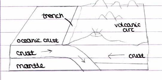
Convergent/Destructive Plate Boundary:
- It happens at the oceanic-continental boundary.
- Destructive plate boundaries occur when two plates are moving together. Plates move as a result of convection currents in the mantle.
- The oceanic plate subducts and breaks down, creating magma. Sea water drags down with it, reducing the density of magma and enabling it to rise through rocks.
- Magma rises through weaknesses in the overlying continental crust, forming volcanoes on the surface. Volcanoes become extremely explosive as the water erupts as steam.
- The sinking oceanic plate can stick to the continental plate as the movement is not gentle—pressure builds up due to friction, and release is felt as an earthquake (violent).
- The collision of the plates buckles the leading edge of the continental plate, forming fold mountains.
- The lighter granitic continental plate subducts beneath the more dense basaltic (volcanic rock) oceanic plate (layer in the mantle).
- The ocean at this point, known as an ocean trench, forms the deepest parts of our ocean.
Divergent/Constructive Plate Boundary:
- This phenomenon occurs when two plates are moving apart, causing new basaltic material to rise to the surface and form a new seabed.
- The vast majority of the creation of new crust happens in the oceans, forming ridges and chains of submarine volcanoes (e.g., the Mid-Atlantic Ridge). Sometimes these volcanoes rise to the surface to create islands (through continuous build-up of lava), eventually breaking through the surface of the water (e.g., Iceland).
- Rising convection currents in the mantle cool and spread outwards as they near the surface, pulling the crust apart and creating fissures and faults through which magma can reach the surface.
- Magma is basalt, hot, and runny. It creates lava flows, shallow-sided volcanoes, and shield volcanoes.
- Eruptions don't tend to be explosive, as magma can gently rise to the surface and easily break through.
- Friction from tearing apart the plates causes earthquakes. These earthquakes are small and don't cause much damage.
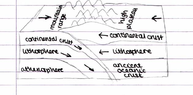
Convergent/Collision Plate Boundary:
- Between two continental plates,
- The continental crust here is 2x the average thickness (≈75 km).
- The region's volcanic activity ends when the continental crust thickens. Any magma moving up would solidify before reaching the surface.
- The Eurasian plate was partly crumpled and buckled above the Indian plate, but due to its low density and high buoyancy, neither was forced down.
The continental crust thickens by folding and faulting.
- Neither of the two continental crust plates subducts as they move toward each other. Instead, they crumple and buckle against each other.
- Large pieces of crust crashing into each other generate friction, which causes earthquakes to occur frequently and can be very large.
Transform/Conservative Plate Boundary:
- It occurs when plates are sliding past one another in opposite directions or the same direction at different speeds.
- E.g., the west coast USA fault is the boundary between the NA and Pacific plates.
- There is no magma or subduction, hence no plate creation or destruction occurs. Volcanoes don’t occur here.
- Sliding isn't smooth because of friction between two plates, which causes extreme stresses to build up in crustal rocks. Pressure released = Earthquake. Earthquakes here occur frequently and can be large.
- The size of an earthquake relates to the frequency of movement. E.g., there's a long period without movement; pressure builds up, and eventual movement will be greater, generating more energy and a higher magnitude earthquake.
Diagrams of Plate Boundaries
Convergent/Destructive
Divergent/Constructive
Convergent/Collision
Note for earthquake formation:
1) Friction
2) Pressure build-up
3) Release
Volcanoes
- A volcano is an opening in the crust through which lava erupts.
- 500 million people are at risk of volcanic eruptions globally.
- Plate margins, where plate movement allows magma to rise, are home to volcanoes.
Volcano Types
- Active volcanoes: Tend to erupt more often and may again.
- Dormant volcanoes: Have not erupted for many centuries but may erupt again.
- Extinct volcanoes: No one expects them to erupt again in thousands of years.
- Volcanologists sometimes cannot tell whether a volcano is dormant or extinct.
Measuring Volcano Magnitude
- Using VEI (volcano explosivity index).
- It evaluates destructive power using a scale from 1 to 8.
- Modern humans have not experienced anything beyond the number 6.
Supervolcanoes, such as Yellowstone, erupted approximately 600k years ago.
Causes of Contrasting Volcanic Hazards
- Various types of magma on Earth can create different types of volcanoes.
- Runny magma allows gas to escape easily, preventing an explosion.
Magma comes out of the mountain and flows down the sides.
- Viscous magma, where gas cannot escape, builds up until it explodes, causing landslides and huge clouds of burning rock and gas to destroy everything around it.
- The viscosity of lava depends on silica content.
Volcanic Hazards
- Lahar: A volcanic mudslide happens when rain or snow combines with volcanic ash.
- Pyroclastic flow: Deadly hot ash and gas clouds that sweep up to 200 km/h.
- Lava flow: A volcano's ejected magma travels down its sides.
- Tephra: Material ejected by the volcano can be small (ash) or large (bombs).
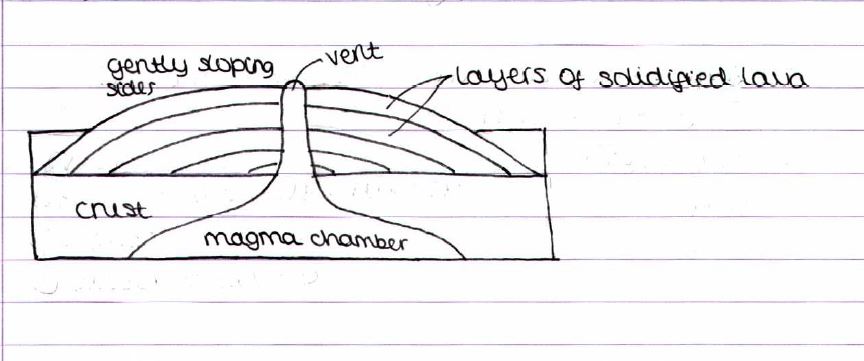
Types of Volcanoes
Shield Volcanoes: Usually form at hotspots/constructive plate boundaries from non-explosive eruptions. Constructive/Divergent and hotspot plate boundary. Example: Mauna Kea, Kilauea. Basaltic, low-viscosity lava. Lava can flow quite far before solidifying. Effusive (gentle) and low risk; frequent eruptions. The eruptions are consistently effusive and predictable, scoring approximately 2 on the Volcanic Explosivity Index (VEI). The fast-flowing, runny lava keeps the slopes from being too steep. The shield exhibits a significant width in relation to its height, and it has the potential to reach significant heights.
Composite Volcanoes: They form from both explosive and non-explosive eruptions. Destructive/Convergent (due to subduction). Example: Mt. Vesuvius, Mt. Fuji. Andesitic lava: high silica percentage. Thick and sticky. Flows slowly and travels short distances. Infrequent and high risk: i.e., violent. There may be an explosive or non-explosive, unpredictable nature. Usually 4+ on VEI. Lava flows slowly and settles quickly, forming a conical shape. They stand tallest on land, frequently surpassing their width.
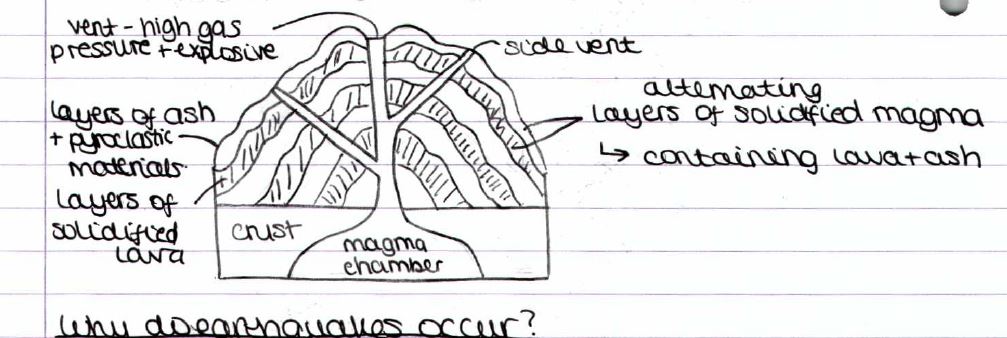
Why do earthquakes occur?
- Earthquake (aka tremor/trembler): Shaking of Earth's surface resulting from the sudden release of energy in Earth's lithosphere that creates seismic waves.
- Earthquakes range in size from very weak ones to large shakers that cause widespread devastation.
- Earthquakes can occur at all plate boundaries but vary in magnitude, duration, and depth of focus. Variations in these factors may affect the impacts of the earthquake.
How an earthquake occurs?
1) Convection currents cause the plates to move; the plates constantly move, and their edges are rough.
2) Friction causes plates to rub against each other and become stuck or caught.
3) Convection currents try to move the plates; this builds up the pressure.
4) Pressure eventually exceeds friction, leading to a sudden release of energy.
5) The plates move rapidly, and there is a large jolt—this is the earthquake.
6) Plates eventually come to rest after smaller movements—aftershocks.
Destruction caused by earthquakes:
- Earthquakes are intense vibrations within Earth's crust that cause the ground to shake, releasing pressure build-up in the crust.
- >90% occur at convergent plate boundaries.
- Focus: Point where earthquake occurs underground.
- Shockwaves radiate out of focus.
- The epicentre, a point on the ground directly above the focus, is where an earthquake exerts its greatest force.
Factors affecting destruction:
1) Magnitude of earthquake:
This isn't the only factor impacting the severity of impacts.
Two earthquakes of the same magnitude cannot have the same level of impact.
Although magnitude plays a large role, there are also other factors seemingly more important.
2)Depth of focus:
The earthquake's energy weakens as it travels, resulting in a less severe deep focus.
Shallow focus is much more severe as the earthquake’s energy reaches the surface quickly.
3) Type of plate boundary:
It's crucial to note that distinct plate boundaries possess varying focal depths.
Transform/Conservative: Shallow focus = Moderate magnitude.
Convergent/Collision: Refers to a focal depth that ranges from shallow to intermediate, resulting in a moderate magnitude.
Destructive/Convergent: Refers to a range of focal depths, from shallow to deep, with the majority falling within the shallow range. Highest magnitude at this boundary.
4) How developed a country is:
Developed: Stronger, earthquake-resistant buildings.
A better-educated population.
Better hospitals and response units.
More money to rebuild. People are well connected and hear warnings early.
Developing: Buildings have no regulations; they can fall quickly.
- People with lower levels of education are ill-prepared for an earthquake.
- Rebuilding costs are minimal, yet the effects endure significantly longer.
- No early warnings. Lack of technology + people aren't well-connected.
Tsunamis
- Some earthquakes generate tsunamis as a secondary effect. Tsunamis are exceptionally large waves that have the potential to cause widespread impacts across countries.
- Some countries have attempted to build walls to protect their coastlines from tsunamis.
How do tsunamis form?
1. After an earthquake at a destructive plate boundary.
2. Friction from the subduction of an oceanic plate into the mantle beneath a continental plate causes the plate to stick.
3. Energy accumulates when the friction plate snaps back into position.
4. This phenomenon causes a column of water to shift upward, creating a tsunami.
Why do only some earthquakes form tsunamis?
- Only large earthquakes ≥ 6.5 magnitude can form them.
- To cause vertical movement of the sea floor, an earthquake must occur beneath the ocean, rupture the Earth's surface, and occur at a shallow depth of approximately 70 kilometres.
Tsunami vs. normal wave
- Weather, tides, and currents power normal waves.
- Tsunamis → Powered by geological force.
- Tsunami waves are faster and able to travel over longer distances than normal waves.
Tsunami at sea vs. land
- People may not notice a tsunami passing them at sea, but near land, a tsunami grows by amplification.
What happens to water near land just before a tsunami hits?
- The front of the wave slows down, so the back of the wave catches up, causing a big build-up of water.
- This draws water in from the leading edge, exposing the seabed.
Why do tsunamis cause so many disastrous impacts?
- Surge forward like a flood.
- Water is extremely heavy and hits the coastline with great force.